Kasha Katuwe Tent Rocks National Monument

In my last two posts about the splendor of the hikes you can take around Santa Fe, I headed north of Santa Fe where we scrambled up and down ladders at Bandelier National Monument, and then another day head towards the stark inspirational beauty of Plaza Blanca.  Our third and final hiking excursion during our stay was to Kasha-Katuwe Tent Rocks National Monument, which is between Santa Fe and Albuquerque and about an hour away if you start at either of those cities.

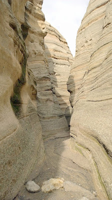
What makes this hike fun is that it’s a relatively easy hike that includes walking through (and a few climbing over rocks) in the slot canyons as well as hiking up to the top of the cliffs for some stunning views of the rocks from bottom to top, if you take the 1.5 mile each way Canyon Trail to the overlook 630 feet up. Then on the way back join up with the rest of the 1.2 mile round trip easy Cave Loop and take the other fork to circle back to the parking area, which also takes you past a man made cave.

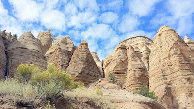
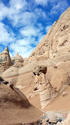
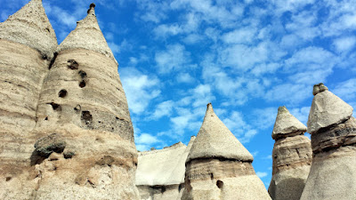
What makes this hike special are the the unique rock formations that are tent like, giving Kasha Katuwe Tent Rocks their name. Kasha Katuwe means White Cliffs in the language of the Cochiti Pueblo people – you drive through some of their tribal lands to get here. We visited on a day after a huge rainstorm, and so the rocks still were retaining the moisture which resulted in more color and being able to really see the geologic layers of all the many thousands of years before us.
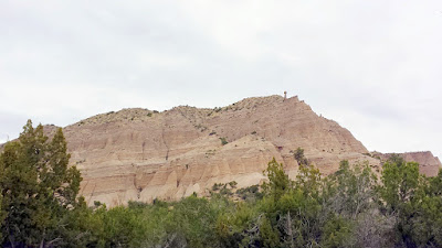
Kasha-Katuwe Tent Rocks National Monument 40 miles S of Sante Fe. Kasha-Katuwe means White Cliffs in the Keresan language of the nearby Cochiti Pueblo. It so happened that there was a big rain storm system that went through earlier in the week though, so instead of being white there is some color in the rock from the absorbed moisture that show off the layers Kasha-Katuwe Tent Rocks National Monument 40 miles S of Sante Fe. Kasha-Katuwe means White Cliffs in the Keresan language of the nearby Cochiti Pueblo. It so happened that there was a big rain storm system that went through earlier in the week though, so instead of being white there is some color in the rock from the absorbed moisture that show off the layers Kasha-Katuwe Tent Rocks National Monument 40 miles S of Sante Fe. Kasha-Katuwe means White Cliffs in the Keresan language of the nearby Cochiti Pueblo. It so happened that there was a big rain storm system that went through earlier in the week though, so instead of being white there is some color in the rock from the absorbed moisture that show off the layers

Walking through the canyons on Canyon Trail, you’ll be able to see the details of these layers up close.
Kasha-Katuwe Tent Rocks National Monument 40 miles S of Sante Fe. Kasha-Katuwe means White Cliffs in the Keresan language of the nearby Cochiti Pueblo. It so happened that there was a big rain storm system that went through earlier in the week though, so instead of being white there is some color in the rock from the absorbed moisture that show off the layers Kasha-Katuwe Tent Rocks National Monument 40 miles S of Sante Fe. Kasha-Katuwe means White Cliffs in the Keresan language of the nearby Cochiti Pueblo. It so happened that there was a big rain storm system that went through earlier in the week though, so instead of being white there is some color in the rock from the absorbed moisture that show off the layers Kasha-Katuwe Tent Rocks National Monument 40 miles S of Sante Fe. Kasha-Katuwe means White Cliffs in the Keresan language of the nearby Cochiti Pueblo. It so happened that there was a big rain storm system that went through earlier in the week though, so instead of being white there is some color in the rock from the absorbed moisture that show off the layers Kasha-Katuwe Tent Rocks National Monument 40 miles S of Sante Fe. Kasha-Katuwe means White Cliffs in the Keresan language of the nearby Cochiti Pueblo. It so happened that there was a big rain storm system that went through earlier in the week though, so instead of being white there is some color in the rock from the absorbed moisture that show off the layers

Kasha-Katuwe Tent Rocks National Monument, taking the Canyon Trail Kasha-Katuwe Tent Rocks National Monument, taking the Canyon Trail

Walking through the canyons, they eventually get tighter into the slot canyons. When you visit, do be aware of any storm systems as slot canyons can be susceptible to flash flooding so take precautions. We saw the trails left behind from the flows of water the day before, but it was all dry for us with some areas of mud for the hike. Of course we weren’t visiting during monsoon season, and I still checked weather reports for flash flood risk.
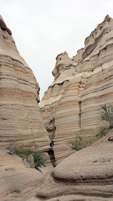
Kasha-Katuwe Tent Rocks National Monument. Part of the trail is going to incude going through some slot canyons that some points require a little scrambling or fit only one person at a time Kasha-Katuwe Tent Rocks National Monument. Part of the trail is going to incude going through some slot canyons that some points require a little scrambling or fit only one person at a time

There may be a few points which require a little climbing over rocks and under a boulder to get through, one person at a time. That just makes it more fun, right?
Kasha-Katuwe Tent Rocks National Monument. Part of the trail is going to incude going through some slot canyons that some points require a little scrambling or fit only one person at a time Kasha-Katuwe Tent Rocks National Monument. Part of the trail is going to incude going through some slot canyons that some points require a little scrambling or fit only one person at a time Kasha-Katuwe Tent Rocks National Monument. Part of the trail is going to incude going through some slot canyons that some points require a little scrambling or fit only one person at a time Kasha-Katuwe Tent Rocks National Monument. Part of the trail is going to incude going through some slot canyons that some points require a little scrambling or fit only one person at a time

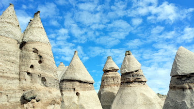
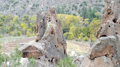
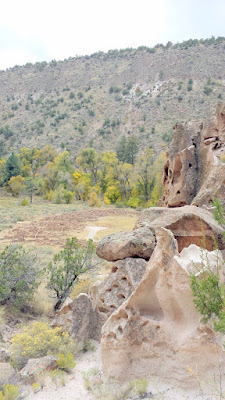
After the slot canyon section, you will come to the clearly formulated tent rocks. The cloudy skies cleared for us and provided a brilliant New Mexico blue sky contrasting background. The tent features of the rocks, also called hoodoos, might bring to mind the otherworldly “fairy chimneys” of Cappadocia in Turkey, which is the only other place in the world with these formations. In both cases, it was volcanic activity that then eroded over time into the cliffs, canyons, and cones of softer pumice and tuff.
Kasha-Katuwe Tent Rocks National Monument Kasha-Katuwe Tent Rocks National Monument Kasha-Katuwe Tent Rocks National Monument Kasha-Katuwe Tent Rocks National Monument

Sometimes the softer rock portion is topped by a harder caprock, often resulting in fascinating rocks that appear to be barely balanced.
Kasha-Katuwe Tent Rocks National Monument were formed by volcanic activity that then eroded over time into the cliffs, canyons, and cones of softer pumice and tuff often topped by a harder caprock, often resulting in fascinating rocks that appear to be barely balanced. Kasha-Katuwe Tent Rocks National Monument were formed by volcanic activity that then eroded over time into the cliffs, canyons, and cones of softer pumice and tuff often topped by a harder caprock, often resulting in fascinating rocks that appear to be barely balanced.

And you may even see shapes that you recognize in the rock formations, similar to seeing shapes in clouds… I felt like I was passing guardians along the path at both these points here.
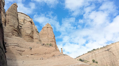
Kasha-Katuwe Tent Rocks National Monument. Some of the structures have caprocks perched on top of them; an amazing balancing act on the part of Mother Nature. This one looked like a little person Kasha-Katuwe Tent Rocks National Monument. Some of the structures have caprocks perched on top of them; an amazing balancing act on the part of Mother Nature. This one looked like a little person

As you begin to ascend steeply at one point on the trail, you get a chance to see the tent rocks from bottom to top to from above as you continue to walk up the path. The top of the mesa affords you a view over the Tent Rock formations,  down Peralta Canyon and across to the far away Sangre de Cristo and Jemez Mountains. This was my favorite view of the hike.
Kasha-Katuwe Tent Rocks National Monument. Now we are going up a pretty steep part of the hike so that we get a chance to see the tent rocks from above on the cliffs. Kasha-Katuwe Tent Rocks National Monument. Now we are going up a pretty steep part of the hike so that we get a chance to see the tent rocks from above on the cliffs. Kasha-Katuwe Tent Rocks National Monument. Now we are going up a pretty steep part of the hike so that we get a chance to see the tent rocks from above on the cliffs. Kasha-Katuwe Tent Rocks National Monument. Now we are going up a pretty steep part of the hike so that we get a chance to see the tent rocks from above on the cliffs.

Here is the  famous view of the Tent Rocks at Kasha-Katuwe and the gorgeous landscape for miles and miles around us.
Kasha-Katuwe Tent Rocks National Monument. The reward for those steep rock stairs - a view of the tent rocks from above, and the gorgeous landscape for miles and miles around us Kasha-Katuwe Tent Rocks National Monument. The reward for those steep rock stairs - a view of the tent rocks from above, and the gorgeous landscape for miles and miles around us

There’s a few more cool spots as you walk towards the end of the trail before you turn around go back and look down from the top at some of the canyons you had walked through earlier and also see a few more formations.

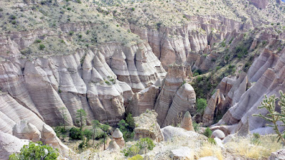
Looking into the canyon of Kasha-Katuwe Tent Rocks National Monument from the cliff top. Looking into the canyon of Kasha-Katuwe Tent Rocks National Monument from the cliff top. Looking into the canyon of Kasha-Katuwe Tent Rocks National Monument from the cliff top.

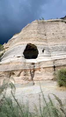
As you head back, you should get back on the other half of the Cave Loop trail where it branched, you follow it so that you will eventually get to where can view a manmade cave. The cave still has blackened walls from cooking fires, and notice how it’s high off the ground for safety from animals an weather and enemies.
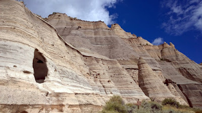
Cave at Kasha-Katuwe Tent Rocks National Monument Cave at Kasha-Katuwe Tent Rocks National Monument Cave at Kasha-Katuwe Tent Rocks National Monument

Then when you are almost at the parking lot you will walk past more tent rocks which are more triangular and almost like teepees. I swear there’s a face in one of them…
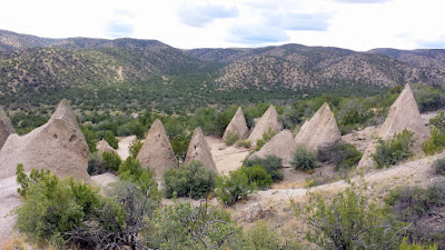
Kasha-Katuwe Tent Rocks National Monument Kasha-Katuwe Tent Rocks National Monument Rock Face at Kasha-Katuwe Tent Rocks National Monument

In the parking lot, besides a self pay station for the park admission, there is a restroom, as well as several picnic tables for eating before or after your hike if you wish. There are animal friends around hoping you will picnic.
Kasha-Katuwe Tent Rocks National Monument wildlife friend we encountered by the parking lot by the trailhead Kasha-Katuwe Tent Rocks National Monument wildlife friend we encountered by the parking lot by the trailhead

On the trail we encountered 3 other wildlife “friends”. I would not call them my friends, but F was pleased. This is pretty consistent with all our hikes – he’s always looking for all wildlife while I’m mesmerized by the views and getting them from different angles.
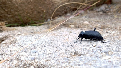
Kasha-Katuwe Tent Rocks National Monument wildlife friend we encountered on the trail Kasha-Katuwe Tent Rocks National Monument wildlife friend we encountered on the trail

As I said before, of our 3 nature day trips, this was the most fun for hiking because of the variety in the path. We rewarded ourselves on our way back to Santa Fe by stopping at Duel Brewery, which specializes in Belgian style beers .They also have a tasting room under construction in Albuquerque,, so check for an update on their website because you might find it on your way to stop by too even if driving back to ABQ instead. The tasting room we visited at Parkway Drive in Santa Fe also showcases lots of paintings. They offer some light food of cheese, meat or vegetable plates to go with the beer.
Duel Brewing and Taproom specializes in Belgian Style beers. They also had a large variety of art in their tasting room. Duel Brewing and Taproom specializes in Belgian Style beers. They also had a large variety of art in their tasting room. Duel Brewing and Taproom specializes in Belgian Style beers. They also had a large variety of art in their tasting room. Duel Brewing and Taproom specializes in Belgian Style beers. They also had a large variety of art in their tasting room. Duel Brewing and Taproom specializes in Belgian Style beers.

What do you think of the tent rocks? Have you been to New Mexico before, what was your favorite day trip or hike? Of the three easy hiking day trips I’ve now shared, which sounds or looks most appealing to you?
Looking into the canyon of Kasha-Katuwe Tent Rocks National Monument from the cliff top.

Here’s the summary of my series of posts on Santa Fe, New Mexico Travels

Signature

Santa Fe Travels: Bandelier National Monument

I spent a week in Santa Fe, and was surprised at how much I really enjoyed it. I knew it would offer great arts, culture, and wonderful dining, but I underestimated it’s powerful combination of history and nature.

My first taste of this was visiting the famous Bandelier National Monument. Going in, I only knew they were ruins with some ladder climbing. Actually, Bandelier National Monument is a National Park that covers 33,000 acres that includes multiple signs of the people who have lived here in the past 11,000 years in various locations. They are open daily, year round, from dawn to dusk, and includes a campground (Juniper Campground) and a Visitor Center (9 AM -6 PM mid May – October, 9 AM -4:30 PM off peak season).

During this peak season, during peak times, the park limits congestion as well as pollutants by requiring in most cases visitors to take a free shuttle bus into the park with a few exceptions based on time, campers, and bicycles, going to other trails besides the main one (Main Loop Trail) for instance. There is ample parking by where the shuttle bus picks up at the White Rock Visitor Center, and by riding the bus you can enjoy some of the views on the way to the Bandelier Visitor Center.

Bus to Bandelier National Monument is required to limit congestion and pollutants during peak season, peak times Bus to Bandelier National Monument is required to limit congestion and pollutants during peak season, peak times

When we arrived, a park ranger was standing outside to greet our bus with a short welcome as well as telling us about the two main sites along the Main Loop Trail. Many people might only visit the village of Tyuonyi and Cliff Dwellings and turn around after an approximately 1 hour round trip and easy 1 1/4 mile total walk. Others like F and I went on for an extra 30 minutes and 1/2 mile each way to Alcove House which has a steep 140 foot climb on 4 ladders –  so definitely is not for those afraid of heights.

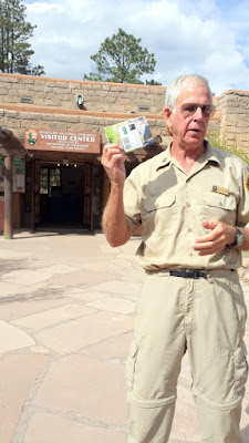
There is a little pamphlet the ranger pointed out that besides the $12 entrance fee for the park, that you can purchase for an additional $1 to give you more information about everything you see. I think the mini guide is highly worth the small additional fee as it gives you information at 21 numbered points along the Main Loop Trail.
Bandelier National Monument, arriving at the visitor center the bus was greeted by a ranger who gives a quick couple minute intro

Here’s a little look at some of the wonderful views while I’m still standing in the parking lot of the Bandelier Visitor Center… we haven’t even walked into the visitor center yet. Also make sure you do your bathroom stop here before you to go out as there are no facilities past the visitor center along the trails! There is also a small cafe for food and drinks if you wish.
Bandelier National Monument - view at the Visitors Center parking lot

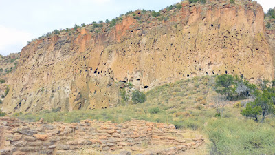
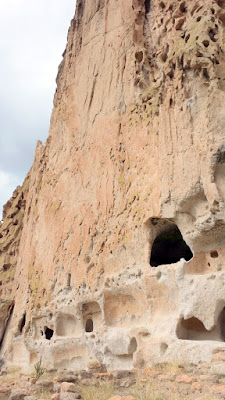
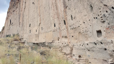
The pink rock of the canyon wall here in the Frijoles Canyon is volcanic ash that compacted over time into a soft crumbly rock called tuff. Tuff is very easily eroded wind and rain, with some components of the tuff eroding more easily than others so that over time the exposed rock takes on a Swiss Cheese appearance. You can see then why this area was popular with the Ancestral Pueblo people (also known as Anasazi) who could use tools to enlarge openings and create stone dwellings.
The pink rock of the canyon wall here in the Frijoles Canyon of Bandelier National Monument may look like sandstone, but it is actually volcanic ash that compacted over time into a soft crumbly rock called Tuff. Tuff is very easily eroded wind and rain, with some components of the tuff eroding more easily than others so that over time the exposed rock takes on a Swiss Cheese appearance. The pink rock of the canyon wall here in the Frijoles Canyon of Bandelier National Monument may look like sandstone, but it is actually volcanic ash that compacted over time into a soft crumbly rock called Tuff. Tuff is very easily eroded wind and rain, with some components of the tuff eroding more easily than others so that over time the exposed rock takes on a Swiss Cheese appearance.

Tyounyi and Cliff Dwellings

Let’s start with the Main Loop Trail towards Tyounyi and Cliff Dwellings. This is the most popular route, a 1.2 mile loop trail that is easy and may take you an hour round trip and includes the 21 stops along Tyounyi pueblo and Cliff Dwellings before you loop back described in the $1 mini guide from the visitor center.

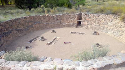
The first thing you will come across is a Kiva, an underground structure that serves as a community center. Back in the day, it would have been covered by a roof of wood and dirt that was plastered with mud strong enough so people could walk on it. and the roof itself is also supported by six wooden pillars. People would have entered the darkened underground room lit by torches by climbing a ladder down.
Bandelier National Monument in New Mexico, Kiva, an underground structure that serves as a community center

Not far after the kiva you will encounter the walls of the village of Tyuonyi, which is only one of several large puebelos inside the Bandelier National Monument. Tyuonyi was about two stories and four hundred rooms.
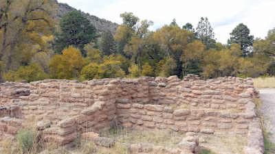
These walls belong to the village of Tyuonyi, one of several large pueblos located within Bandelier National Monument. One to two stories high, Tyuonyi contaiend about 400 rooms and housed about 100 people. Access to the village was through a single ground level opening

You won’t see this view until you are further along the path, but I’ll show them now to help give you an idea of the size of Tyuonyi village.
These walls belong to the village of Tyuonyi, one of several large pueblos located within Bandelier National Monument. One to two stories high, Tyuonyi contaiend about 400 rooms and housed about 100 people. Access to the village was through a single ground level opening These walls belong to the village of Tyuonyi, one of several large pueblos located within Bandelier National Monument. One to two stories high, Tyuonyi contaiend about 400 rooms and housed about 100 people. Access to the village was through a single ground level opening

One of the fascinating thoughts I had was how Tyuonyi was constructed six hundred years ago – but at those same times, the caves were also occupied. You can even see the cliff dwellings now from Tyounyi – and the photos above were when I was at the cliff dwellings look back upon Tyuonyi. It makes you wonder what determined who lived in the caves or in the canyon. Family? Clan? Preference, like the way some people choose to live in the city and others in the suburbs?
Bandelier National Monument. In the forefront of the photo, the walls of the village of Tyuonyi. Even further back, you can see the walls of the Cliff Dwellings where there are cave rooms we are about to start walking towards. Tree ring dating shows the construction of these homes was more than 600 years ago, and the caves were occupied at the same time. The choice to live in the caves or in the canyon bottom may have been based on family, clan custom, or maybe simply preference Bandelier National Monument. In the forefront of the photo, the walls of the village of Tyuonyi. Even further back, you can see the walls of the Cliff Dwellings where there are cave rooms we are about to start walking towards. Tree ring dating shows the construction of these homes was more than 600 years ago, and the caves were occupied at the same time. The choice to live in the caves or in the canyon bottom may have been based on family, clan custom, or maybe simply preference

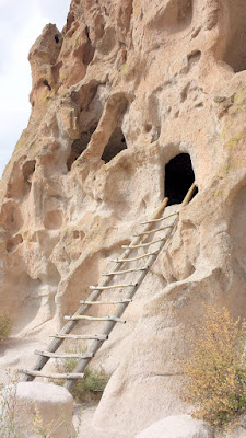
There’s a fork slightly after the Tyuonyi village where you can choose to go to the first set of Cliff Dwellings, called Talus Houses, but which have several stairs, or you can take the trail to the Cliff Dwellings called Long House that has fewer stairs. We visited both so you can see the difference between the two. The Talus Houses will have ladders to visit inside the dwellings, but the Cliff Dwellings will not.

The Cliff Dwellings in the Talus Houses area are many cave rooms / cavates and alcoves, often with ceilings blackened by soot to harden them, and perhaps some rock drawings. Be sure to stay on the trail and only enter caves that have ladders because you don’t want to contribute to eroding the tuff.
These cave rooms in the Bandelier National Monument, classified as cavates, were dug out of the cliff wall. These cave rooms in the Bandelier National Monument, classified as cavates, were dug out of the cliff wall. These cave rooms in the Bandelier National Monument, classified as cavates, were dug out of the cliff wall. Be sure to stay on the trail and only enter caves that have ladders because you don't want to contribute to eroding the tuff. These cave rooms in the Bandelier National Monument, classified as cavates, were dug out of the cliff wall to create these cliff dwellings.

And here’s another view of Tyounyi Village from the viewpoint of the Cave Dwellings
Bandelier National Monument. View of the village of Tyuonyi from one of the cavates of the Cliff Dwellings. Tree ring dating shows the construction of Tyounyi was more than 600 years ago, and the caves were occupied at the same time. The choice to live in the caves or in the canyon bottom may have been based on family, clan custom, or maybe simply preference Bandelier National Monument. View of the village of Tyuonyi from oby the Cliff Dwellings. Tree ring dating shows the construction of Tyounyi was more than 600 years ago, and the caves were occupied at the same time. The choice to live in the caves or in the canyon bottom may have been based on family, clan custom, or maybe simply preference Bandelier National Monument. View of the village of Tyuonyi from oby the Cliff Dwellings. Tree ring dating shows the construction of Tyounyi was more than 600 years ago, and the caves were occupied at the same time. The choice to live in the caves or in the canyon bottom may have been based on family, clan custom, or maybe simply preference Bandelier National Monument. View of the village of Tyuonyi from oby the Cliff Dwellings. Tree ring dating shows the construction of Tyounyi was more than 600 years ago, and the caves were occupied at the same time. The choice to live in the caves or in the canyon bottom may have been based on family, clan custom, or maybe simply preference

The trail here zig zags with stairs through the cliffs, and provides access to more dwellings. The Ancestral Pueblo were small people, averaging five feet for women and five feet six for men, and living to about 35 years. The fact that there are many homes in this row along the canyon wall made me wonder if it was humming with activity like the village of Tyuonyi, or maybe this was the quieter suburbs with slightly more privacy? Or was this the “city high rise” life of its time?
These cave rooms in the Bandelier National Monument, classified as cavates, were dug out of the cliff wall to create these cliff dwellings. These cave rooms in the Bandelier National Monument, classified as cavates, were dug out of the cliff wall to create these cliff dwellings. These cave rooms in the Bandelier National Monument, classified as cavates, were dug out of the cliff wall to create these cliff dwellings. These cave rooms in the Bandelier National Monument, classified as cavates, were dug out of the cliff wall to create these cliff dwellings.

Some of the pathways were quite slim, fitting only one person. You can also see when we looked back why we were pretty much alone or only with a handful of people – there was a big storm on the horizon, including lightening. Fortunately the wind blew the storm a different direction past us. I didn’t encounter it until much later in the evening, while driving from back to our lodgings after a post hike stop at Santa Fe Brewing.
Looking back from the Talus Houses Cliff Dwellings in Bandelier National Monument at the storm on the horrizon, and the slim pathway fitting only one person we went through

Now we have arrived at the part of Cliff Dwellings known as Long House. These are multi-storied dwellings along a cliff base and with carved petroglyphs. You can count the stories by counting the rows of holes. Extended families lived together with each group having their own storage room, sleeping quarters, and kiva. There are no ladders to visit any of these dwellings.
These cave rooms in the Bandelier National Monument, classified as cavates, were dug out of the cliff wall to create these cliff dwellings. This is Long House, multi-storied dwellings along a cliff base and with carved petroglyphs. You can count the stories by counting the rows of holes. These cave rooms in the Bandelier National Monument, classified as cavates, were dug out of the cliff wall to create these cliff dwellings. This is Long House, multi-storied dwellings along a cliff base and with carved petroglyphs. You can count the stories by counting the rows of holes. These cave rooms in the Bandelier National Monument, classified as cavates, were dug out of the cliff wall to create these cliff dwellings. This is Long House, multi-storied dwellings along a cliff base and with carved petroglyphs. You can count the stories by counting the rows of holes. These cave rooms in the Bandelier National Monument, classified as cavates, were dug out of the cliff wall to create these cliff dwellings. This is Long House, multi-storied dwellings along a cliff base and with carved petroglyphs. You can count the stories by counting the rows of holes.

Alcove House

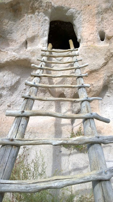
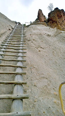
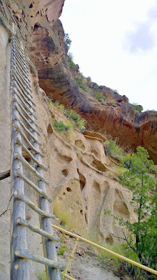
Walk another 30 minutes, about 1/2 a mile one way, rather than turning around to return to the visitors center if you want to visit Alcove House. It’s an easy walk, but once you are at Alcove House there is nothing to look at unless you brave the ladders – 140 feet of 4 steep ladders.
Bandelier National Monument, visiting Alcove House. After Long House Cliff Dwellings, it's an easy walk 1/2 mile walk to here, but once you are at Alcove House there is nothing to look at unless you brave the ladders - 140 feet of 4 steep ladders. Bandelier National Monument, visiting Alcove House. After Long House Cliff Dwellings, it's an easy walk 1/2 mile walk to here, but once you are at Alcove House there is nothing to look at unless you brave the ladders - 140 feet of 4 steep ladders.

I did mention they were steep right? It’s the same way going up and down – only the ladders.
Bandelier National Monument, visiting Alcove House. After Long House Cliff Dwellings, it's an easy walk 1/2 mile walk to here, but once you are at Alcove House there is nothing to look at unless you brave the ladders - 140 feet of 4 steep ladders. Bandelier National Monument, visiting Alcove House. After Long House Cliff Dwellings, it's an easy walk 1/2 mile walk to here, but once you are at Alcove House there is nothing to look at unless you brave the ladders - 140 feet of 4 steep ladders to reach an alcove area.

You are climbing to the top to reach a large alcove area.
Bandelier National Monument, visiting Alcove House. After Long House Cliff Dwellings, it's an easy walk 1/2 mile walk to here, but once you are at Alcove House there is nothing to look at unless you brave the ladders - 140 feet of 4 steep ladders to reach an alcove area. Bandelier National Monument, visiting Alcove House. After Long House Cliff Dwellings, it's an easy walk 1/2 mile walk to here, but once you are at Alcove House there is nothing to look at unless you brave the ladders - 140 feet of 4 steep ladders to reach an alcove area. Bandelier National Monument, visiting Alcove House. After Long House Cliff Dwellings, it's an easy walk 1/2 mile walk to here, but once you are at Alcove House there is nothing to look at unless you brave the ladders - 140 feet of 4 steep ladders to reach an alcove area.

Eats and Drinks

On the way to Bandelier National Monument, consider stopping to eat before or after your visit at Gabriel’s. We happened to pick Gabriel’s to fuel us, and then went to Santa Fe Brewing Company (which is just a simple no frills tasting room with beer only) after the park visit.

Here’s the view just from the parking lot! There is some outdoor seating that has this view too. There really is something about how blue the skies are in this area.
we stop for lunch at Gabriel's which had this view from their parking lot. There really is something about how blue the skies are in this area Lunch at Gabriel's, just outside Santa Fe and on the way to Bandelier National Monument Lunch at Gabriel's, just outside Santa Fe and on the way to Bandelier National Monument  Lunch at Gabriel's, it was too cool outside to sit on the patio but there was a great view

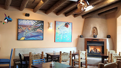
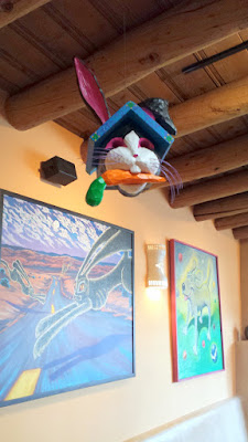
I also loved how the inside is full of unique bold bright Southwest art with nods to nature, especially the ornamental birdhouses.
Lunch at Gabriel's, the inside was pretty fun with lots of cool art and these fun ornamental birdhouses you see hanging Lunch at Gabriel's, the inside was pretty fun with lots of cool art and these fun ornamental birdhouses you see hanging Lunch at Gabriel's, the inside was pretty fun with lots of cool art and these fun ornamental birdhouses you see hanging Lunch at Gabriel's, the inside was pretty fun with lots of cool art and these fun ornamental birdhouses you see hanging
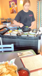
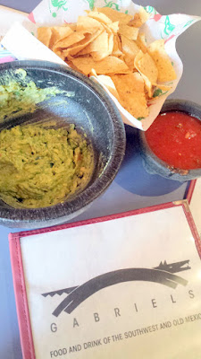
The complimentary chips and salsa were good, but we also added in some of the tableside made guacamole
Lunch at Gabriel's, the complimentary chips and salsa were good, but we also added in some of the tableside made guacamole Lunch at Gabriel's, the complimentary chips and salsa were good, but we also added in some of the tableside made guacamole Lunch at Gabriel's, the complimentary chips and salsa were good, but we also added in some of the tableside made guacamole Lunch at Gabriel's, the complimentary chips and salsa were good, but we also added in some of the tableside made guacamole

For the vegetarian, you have choices like the vegetarian Black Bean Burrito with southwestern style Black Beans and served with rice and corn. Also available were vegetarian enchiladas tamales, and fajitas.
Lunch at Gabriel's, Black Bean Burritio with southwestern style Black Beans and served with rice and cor

I was tempted by multiple dishes but eventually picked out the Green Chili Stew (which I forgot to take a photo of, it was a chunks of pork and potatoes stewed in New Mexico green chile served with soft tortillas) and this Puerto Vallarta dish of lump crab, tiger prawns and chicken breast sautéed in a fresh tomato and white wine sauce and topped with melted cheese. I would definitely recommend Gabriel’s and would return myself for more of the menu that I was tempted by!
Lunch at Gabriel's, the Puerto Vallarta dish of lump crab, tiger prawns and chicken breast sautéed in a fresh tomato and white wine sauce and topped with melted cheese

Gabriel's Menu, Reviews, Photos, Location and Info - Zomato

Have you been to New Mexico, or Santa Fe, or Bandelier National Monument? What do you think of the sights I shared at Bandelier? Would you go up and down the ladders of Alcove House?

Here’s the summary of my series of posts on Santa Fe, New Mexico Travels

Signature