


The Samuel H. Boardman State Scenic Corridor is an iconic area of the Oregon Coast and is a state park that you can travel to between Bandon and Brookings offering miles of rock formations among lush green forests with cliff overlooks, sea stacks and arch formations, and quiet beaches. And, it’s all free- no park pass needed. You can make this a day trip as it is just a 2 hour drive between these two seaside towns, but expect to add on a few hours with the many scenic stops and hikes available before and within Samuel Boardman State Park. Even if you do not want to do much hiking, it is still worth a visit as most viewpoints are easy accessible right along the corridor that you can park and do very short walks to viewpoints. Here’s my guide to Samuel H Boardman Scenic Corridor based on my day trip. This was a leisurely drive from after sleeping in and breakfast and first walking Circle in the Sands, to a lunch to go, no hike more then 30 minutes roundtrip, and then returning back to Bandon with a stop at Prehistoric Gardens, all in time for watching sunset at Coquille Point.

I covered Circle in the Sands and the sunset views at Coquille Point already at the linked posts, so this post will focus on my take on a guide to the Samuel H. Boardman State Scenic Corridor iconic views, whimsy nostalgia of the Prehistoric Gardens experience, along with a lunch with a famous hot dog!
Don’t worry whether the weather is sunny which will look beautiful with blue skies and blue seas in your views, or if it is a gloomy grey day that is also IMHO atmospheric: I think all weather conditions make the scenic viewpoints look special. I recommend driving from north to south for the trip so you are always pulling to the right side into the viewpoints.

A Famous Oregon Coast Hot Dog
Going south from Bandon, it will be a little less then an hour and a half before you reach the Samuel H. Boardman State Scenic Corridor. It is a scenic drive with ocean views from Port Orford on. Before you reach Port Orford, stop while going through the small town of Langlois at Langlois Market, which is right off the highway.

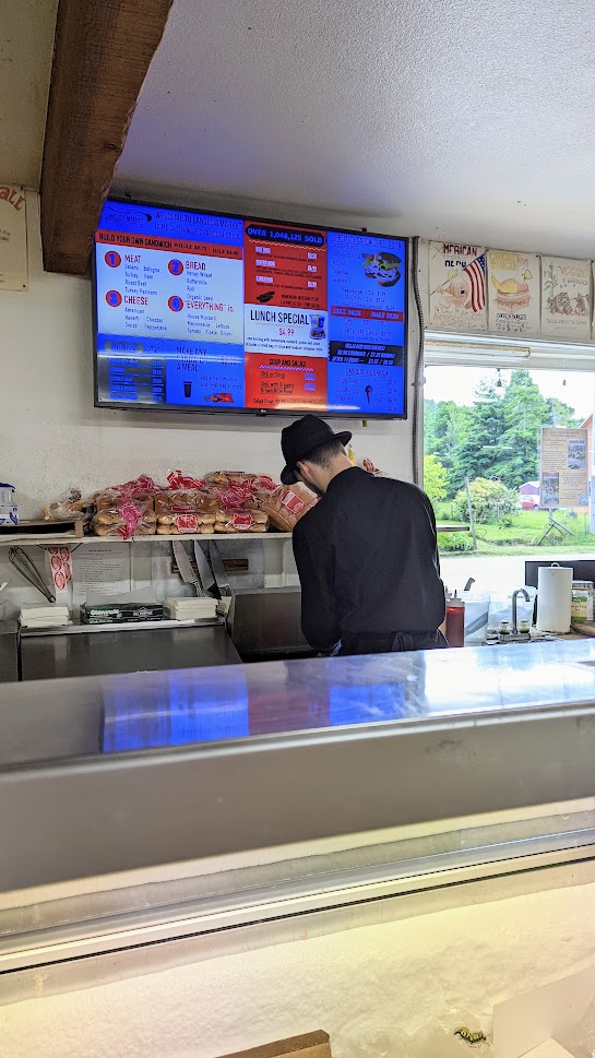
This small town family owned one stop shop is the only market in this rural town and also home of the legendary Langlois hot dog. Besides purchasing convenience market necessities and a surprisingly diverse selection of craft beers and impressive local meat, there is a deli with what they say is home of the “world famous hot dog”.

With that kind of billing, but how can you resist the hot dog? The “everything” dressed hot dog includes homemade mustard (Grandma’s recipe and made fresh everyday), pickle, and onion with a locally made very chubby frankfurter. Or go with the “super dog” and get a hot dog sandwich on a hero roll as seen here!

They can also set you up with your custom sandwich, they have lots of local cheese and tuna and meat and other products if you wander the aisles. So you’re all set to picnic at the outdoor tables right outside for a driving break or take it with you (perhaps even with their $5 growlers) for picnics at any other picturesque stop along the Oregon coast.
Continuing on from Langlois will have you pass though Port Orford and you will drive past the Prehistoric Gardens stop. We decided to head towards the scenic corridor first as there was rain predicted later in the day, and then stop at the Prehistoric Gardens on the way back north. Here’s an example view after Port Orford as we were driving along.


Samuel H. Boardman State Scenic Corridor Iconic Views
The Samuel H. Boardman State Scenic Corridor is a 12 mile stretch of the Oregon Coast Highway (Highway 101) that has various scenic views easily accessible right off the road with pullout areas and parking areas. It is named after the first Oregon State Parks superintendent and who is often called the father of the park system per Oregon Encyclopedia. There is no official visitor center to the Samuel H. Boardman State Scenic Corridor, though there are a few stops with vault restrooms and picnic tables, and it is all free. Just look for signs along the highway indicating you are entering the scenic corridor.
Several of the best viewpoint areas have signs, though not all stops do and may only be hinted at with a pullout area you can see. If there is a parking lot, it is usually a viewpoint just a short walk away from where you park. In the northern portion of the scenic corridor there are more windswept bluffs with more secluded beaches, while as you travel more south it gets flatter into larger sandy swaths of beaches and some grassy meadows.
Heading north to south so you can just keep pulling to the right into the parking lots and pullouts, the iconic views include these major stops that are low effort, mostly park and short walk to a view, or hikes of 30 minutes round trip or less. You can find a map at the state park site for Samuel H. Boardman State Park, and for planning purposes there are 3 public vault restrooms available at the beginning of the park (Arch Rock), middle (Whaleshead Picnic Area) and end (Lone Ranch Beach.) There are many more hikes and viewpoints available then my guide to Samuel H Boardman Scenic Corridor covers, this is my pick for an easy day. My list below is listed sequentially of viewpoints starting from the northern end going south.
Arch Rock
A short 0.3 mile loop well maintained trail takes you from the parking lot to a viewpoint and back – it’s definitely more of a walk to a viewpoint then a hike. This is just your first taste of the ocean and wind carved rock formations in the scenic corridor. This is one of the stops of the Samuel H. Boardman State Scenic Corridor that has a restroom available, and there are also picnic tables. If you visit in the spring and bring binoculars, you may see diverse communities of seabirds using this fortress as isolated breeding and resting habitat. Oregon’s offshore islands throughout the span of the Oregon coast are almost all part of the Oregon Islands National Wildlife Refuge.

From the parking lot, you can also get a view of Spruce Island. There is a parking area if you drive north from Arch Rock if you want a more straight on view, and it has a sign identifying it as Spruce Island Viewpoint. As you can guess by the name, it’s a small island with several Sitka spruce trees.

Secret Beach
This is the first hike in my guide to Samuel H Boardman Scenic Corridor that I would really call a hike instead of a park and walk. You can hike here from either Arch Rock or Thunder Rock Cove which both have parking lots, or you may be lucky and be able to use a pullout area (the third one after Arch Rock, fits about 6 cars, shortly after mile marker 345) between the two which gives you the shortest hike at a 0.2 mile instead of a 2 mile out and back. This shorter hike does include a downward portion on rocks that can be muddy and slippery after rains and you may need to walk around tree roots. Whatever trail you take, if you do hike, be on the lookout to avoid poison oak.
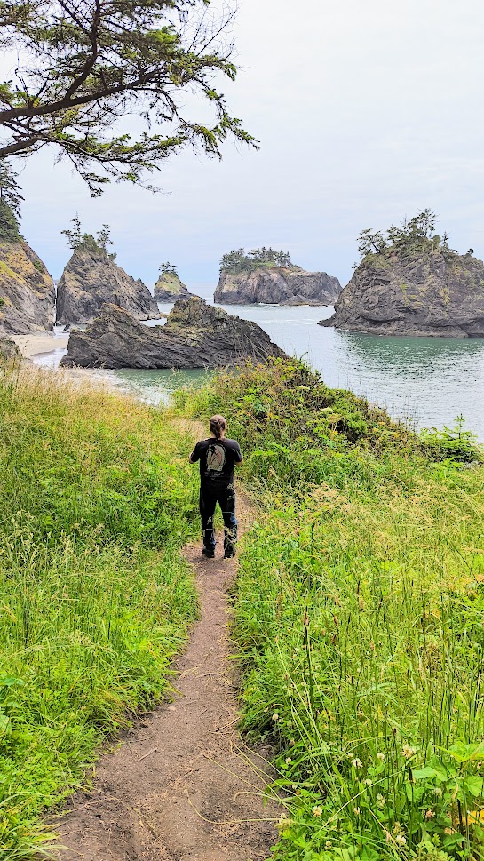

I question how “secret” this beach really is from being known by fellow travelers, but I think it refers more to the fact that this stop has no sign, and that you have to do a hike through the woods to get to a secluded area of beach and rocks, and one of the beach areas is only accessible at low tide. Otherwise, similar to many beaches in Samuel H Boardman Scenic Corridor, the cliffs on one side and sea stacks on the other in the ocean make these beaches feel secluded and private, even though all Oregon beaches are publicly owned and free from the surf line to the vegetation line thanks to the Oregon Beach Bill.

Thunder Rock Cove
This is a 0.75 mile hike that gives you a view of Secret Beach to the north and takes you to a secluded cove with a natural arch and pounding waves that echo on the rock walls of the sea cave and surrounding cliffs – maybe a little like the sound of thunder if you visit when the ocean is swelling before or after a storm. We considered but did not do the hike, but you can find the best details that I had saved about it at this blogpost here from Live and Let Hike.
Natural Bridges
The seven arch rocks and blowholes here of Natural Bridges is easily accessible via a trail that ends in a wooden platform overlooking this vista. It’s another wonderful case of it’s more of a walk to the overlook deck from parking then a hike. Here you’ll also find a memorial to Dr. Samuel Dicken, who first envisioned the Oregon Coast Trail, the 362 mile route through all of the Oregon Coast. You may even run into people that are hiking this trail throughout the Samuel H. Boardman scenic corridor!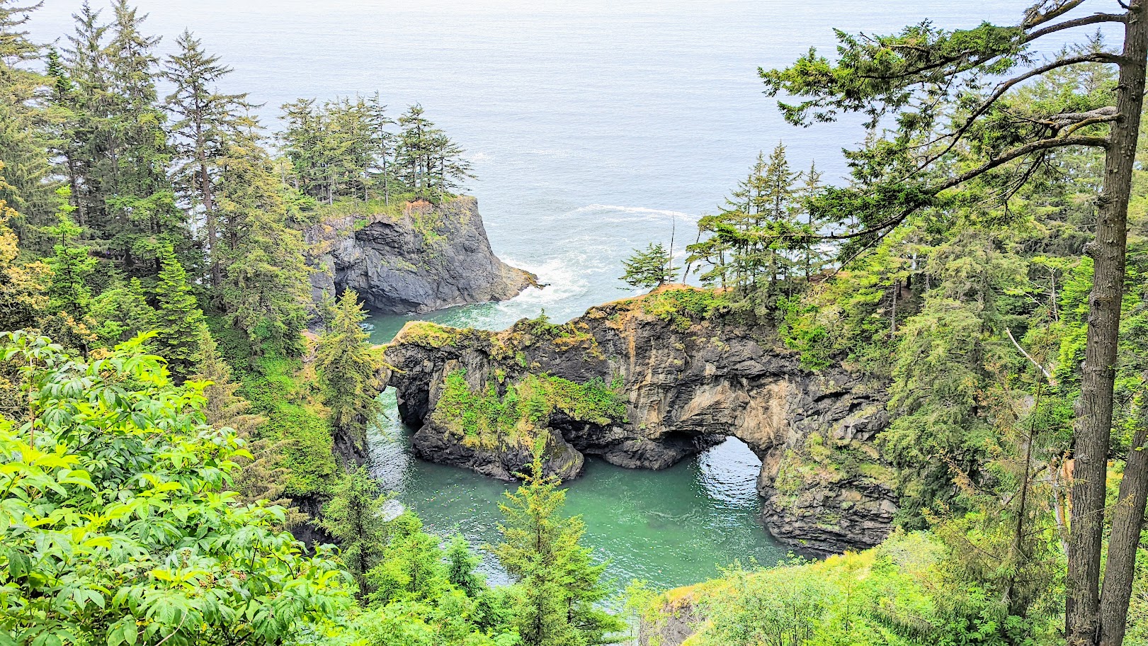

There is non-maintained trail so that you can go down and walk on the natural bridge you see on the left, although we did not go on it. I have read that the trail is pretty steep and can be dangerous when it’s muddy (which it was during our trip) because it gets close to cliff edges on both sides of the trail, though we did see some people on the bridge during our visit. People have fallen and died or needed to be rescued from the trail before (including this summer in 2022), so visit closer at your own risk. If there is a sign asking you not to go further, please don’t. The vista from the viewing platform that you can access from the parking lot is still quite stunning.

Thomas Creek Bridge
The Thomas Creek Bridge is not an official stop, but my guide to Samuel H Boardman Scenic Corridor still includes it because I think it’s scenic and a contrast to the natural bridges you see in the area. Also, trivia: the Thomas Creek bridge is the highest bridge in Oregon, at 345 feet. There are places to park on both sides of the bridge, I took this photo from the area on the northeast side, just steps away from the car (you will need to pullover to an area on the left if driving south). The photo doesn’t do justice to the height as it doesn’t show the ravine that this bridge is crossing over which you seem to need a drone or be walking at the bottom to see, as seen in photos at this That Oregon Life article.

Indian Sands
Indian Sands is a unique viewpoint and area in Samuel H Boardman Scenic Corridor because the sand of these dunes is from eroded sandstone from the cliffs, and not the ocean. For the 1.1 mile short moderate loop trail, sources say to not follow the signs labeled “Indian Sands” in the parking lot but instead from the southern end of the parking area follow an unmarked uphill path going south and dropping 200 feet that then leads to a side path. Following this path will lead you to emerge from the forest onto dunes guarded by small cliffs about 100 feet high, and you can see an arch to the south.
By going south initially on the trail loop, you save yourself a steep ascent if you had gone north (counterclockwise basically) on the loop – though it does mean you will have a descent on the way back. We did not do this hike because trails were muddy and slippery during the day of our visit, and this trail either way includes traversing steep slopes – but it’s short and unique adventure. So it is a stop I had on my wishlist if it had been more dry. For photos of what you might see check out this blogpost from Two Roaming Souls.
Whaleshead Beach
This trail is a moderate 3 mile loop to the beach, but if you walk just a few minutes through the green forest and brush, it will open up so you can see the namesake Whaleshead Island formation that appears like a whale coming up for air, and if the waves hit it right a spout of water spurts almost like a whale blowing. I took this photo and turned around – F didn’t even come down, he was waiting in the car! So basically the equivalent of a stop and literally walk 5 minutes (the time between the timestamp of the bridge photo the below photo is only 9 minutes apart), and then go back, not a hike unless you want it to be.
There is a separate area by Whaleshead which offers picnic tables and a restroom – pull over to the Whaleshead Picnic Area before this instead of the Whaleshead Viewpoint.

Cape Ferrelo Viewpoint and Lone Ranch Beach
By this point in the southern end of the Samuel H Boardman Scenic Corridor, the cliffs are not as high and you can enjoy some grassy headlands on the way to the beachline. Cape Ferrelo Viewpoint is a 300 foot summit that offers panoramic views of the Pacific Ocean and if you’re lucky is a good place for whale watching. Supposedly if it is clear enough you can even see all the way down to the California coast. There also is a convenient bench to sit and gaze upon the vista, and a 1 mile loop to the dramatic cape view.

Sloping meadows lead down to tidepools and offshore rocks and probably the best picnic views of all the park if you take the trail to Lone Ranch Beach. There is a 1.6 loop trail south to the Lone Ranch Beach area from Cape Ferrelo. The trail from Cape Ferrelo to Lone Ranch Beach has some elevation gain and includes long stretches on treeless areas so you can look far up and down the coast – no shade, open to the elements particularly wind and rain, but also spectacular. Another trail takes you north to House Rock Viewpoint – or you can start there with the destination of Cape Ferrelo.
Since it seemed that cape seemed to be a dramatic highlight, we shortcut it by driving to both viewpoints of Cape Ferrelo and Lone Ranch Beach as they both have a parking lot and access and did not hoof it in between the two.
Even if you don’t take the whole trail at Cape Ferrelo, it is worth it to take the path leading to the right/north because there is an interesting spruce tunnel you can walk through. Then, shortly after the tunnel, even though it was the middle of June, there were gorgeous wildflowers brightening up our view of the headlands.


Whether you hike to Lone Ranch Beach or drive there, this is the second hike that I mentioned at the top in my guide to Samuel H Boardman Scenic Corridor. It is worth it to walk from wherever you start to the beach here that offers views of seastacks, easily accessible tidepools, and piles of driftwood shaped by nature like sculptures along the shoreline. The path from the Lone Ranch Beach parking is easy and wheelchair and stroller accessible and there are restrooms at the picnic area by the parking lot. But the best picnic area is by the beach. Here’s a look at Lone Ranch Beach views.


Lone Ranch is the last stop in Samuel H Boardman Scenic Corridor, and you can choose continue to the coastal town of Brookings, or we turned around since our base lodging is still in Bandon, and on the way back north to Bandon stopped for dinosaurs.
Visiting the Prehistoric Gardens
The Prehistoric Gardens is a third generation family-owned roadside attraction along the Oregon Coast Highway since since 1955 that is a self-guided tour through a prehistoric rainforest to encounter 23 full-size model dinosaurs. It’s hard to resist cracking a smile when you see the welcoming dinosaur just outside the doors of this family attraction. Although the size of the dinosaurs was painstakingly recreated to be accurate based on fossil records, the paint coloring and facial expressions may be slightly interpretive.
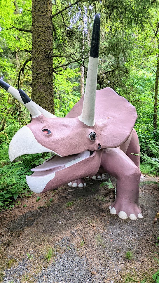
The path winds through a leafy prehistoric forest and is flat and wheelchair and stroller accessible, with signs for each dinosaur identifying it and some interesting fun facts. You can feel the passion of the accountant with a passion for art and amateur paleontology who founded this attraction and crafted each of these dinosaurs, including the 3 story tall brachiosaurus that took 4 years from start to finish. A little kitschy and cheesy fun if you are in the mood for a 30 minute stop. I would recommend this and NOT stopping at the West Coast Game Safari Park which has poor animal care, do not support them with your dollars.


The park was also featured on the show “Strange Inheritance” which gives a lot of context that makes this small park even more enjoyable and hints that with the next generation original owner to daughter to granddaughter to great granddaughter who resides in London, this park may not be able to be sustained for much longer so support it while you can. You can check out the episode on Youtube.
If you are going out to the Oregon Coast, besides enjoying the natural beauty, support the various family owned small businesses as much as you can!
One more post to go to summarize our little couple days trip in Bandon of the series you see below!
Bandon, Oregon Coast Travel Series
- Circles in the Sand at the Oregon Coast
- Sunrise and Moonset at Face Rock Viewpoint
- Sunset at Coquille Point
- Easy Guide to Samuel H Boardman Scenic Corridor – this post
- Art and Eats in Bandon


[…] Easy Guide to Samuel H Boardman Scenic Corridor […]